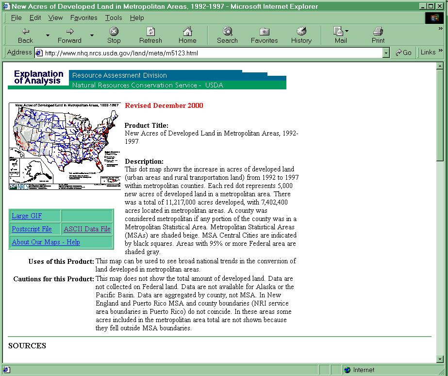
Brookings Institution Sprawl Report New Data Withdrawn by USDA: However, the metropolitan data on which the Brookings Institution report is based is not considered sufficiently reliable for the purposes used. Indeed, the metropolitan area data has been withdrawn from the NRI website . This is not to be confused with the incorrect data released by NRI in December 1999, withdrawn in April and re-released in corrected form in late 2000. The county/metropolitan data that has been withdrawn was a part of the corrected set of data. The problem is that the NRI is not sufficiently accurate at the county level on which metropolitan analysis is based (see below). Unreliability of Data: The unreliability of the NRI for urban area trends is illustrated by examining the change in agricultural land reported by state through the USDA Census of Agricultural (an actual enumeration) and the NRI (a statistical sampling process), both of which are conducted every five years. From 1992 to 1997, the total variation of state level NRI estimates (absolute value), at 36,100 acres, was greater than the actual change recorded in either the Agricultural Census (-13,700 acres) or the NRI (-14,100 acres). The NRI reported changes varied -52.7 percent on average from the Agricultural Census number, while the gross agricultural land figure from the NRI ranged fro 46 percent above to 53 below the Agricultural Census.
Accelleration of Sprawl Inconsistent With Central City Census Gains: Perhaps the greatest surprise out of the 2000 Census is the reversal of population trends in many of the nation's older central cities. For example, New York City reached its population peak, at more than 8 million residents, up nearly 700,000 from 1990. Chicago climbed nearly 200,000 after having lost nearly one million residents over from 1950 to 1990. While it is clear that the greatest portion of metropolitan growth continued to be in the suburbs, an accelleration of the suburbanization trend would seem inconsistent with the central city gains. The reaality of what has occured with respect to urban development and suburbanization will not be reliably available until the Census Bureau reports urbanized area data from the 2000 census. NRI Estimates Tend to be High: The NRI's statistical sampling has produced higher rates of urbanization than the actual full examination of the data performed every 10 years by the US Census. From 1980 to 1990, the Census found that 13,400 additional square miles of land were urbanized. NRI estimated the number 2.2 times as high at 30,000 over a similar 1982 to 1992 period. Either estimate, however, places the amount of urbanization in the nation at a modest level. In 1990, the Census Bureau estimated urbanization at 2.5 percent of the nation's land, while the latest NRI sample estimated urbanization at 4.0 percent. NRI Data Withdrawn Before: The NRI has been plagued with problems in its most recent iteration. When originally released in December 1999, a huge increase in urbanized land was announced through Vice-President Gore's office. But the data was incorrect, which was called to the attention of USDA by Wendell Cox and others. The data was withdrawn and resissued in with much more conservative estimates in late 2000. Even so, questions remain about its data. For example, urbanization in the state of West Virginia is reported to have increased by 175,000 acres from 1992 to 1997. Yet population growth was less than 10,000, suggesting a density of nearly 50 acres for each new household. For comparison, this is nearly 200 times the average sized suburban home, which is built on approximately Ľ acre.
Accessed through
ftp://ftp.nhq.nrcs.usda.gov/pub/outgoing/land/data/m5123d.txt 2001.07.10.
E-Mail:
enquiries@demographia.com
Demographic Briefs |
New Items |
Book Store |
Subscribe (Free)
Corrections Policy, Rights & Permissions
Related Web Site:
|